Join Cyclepath Kelowna's Road Riders Strava Club
Uncover the road routes the locals are riding, make new friends, and challenge yourself. Our Strava Club for road cyclists is dedicated to all things road.
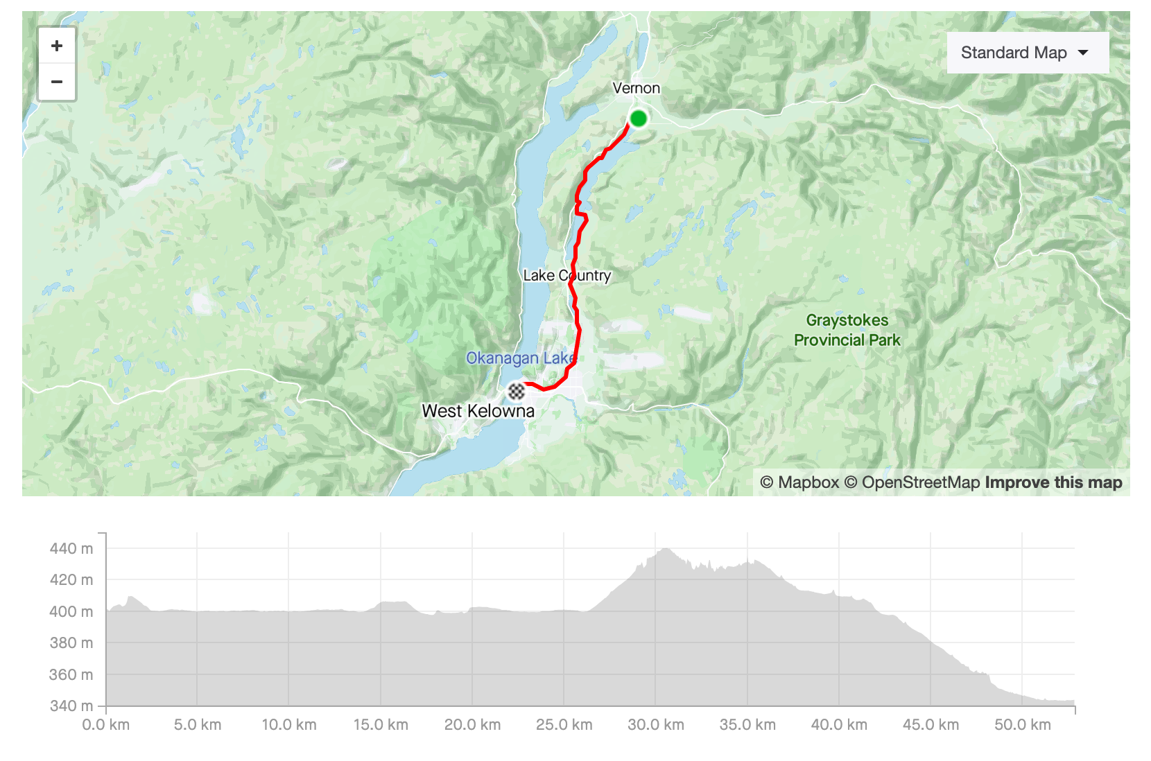
Start at Cyclepath to stock up on nutrition and spares. The warm up is flat all the way, taking you through the orchards to Pandosy Village. The route then takes you along Abbott, Lakeshore and Hobson, affording you views of the lake and some of Kelowna’s finest properties. The first real climb (at 10km in) is where Lakeshore Road gets funky. It turns right at the lights at the top of the climb and you want to stay on it. This part of Lakeshore is pure Okanagan. Wineries, vineyards, lake and mountain views. Rolling with a couple of short and steep hills that pop you out at the top before you get too tired. keep an eye out for the wildlife, plenty of rodents, lots of deer and the occasional bear. One you leave Pandosy Village there are no more fuel stops.
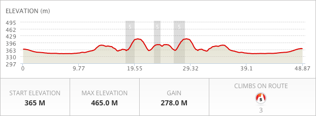
The Rail Trail is an Okanagan staple. It runs from Kelowna to Vernon, passing some iconic sites which are linked together by smooth pavement that's a joy to ride and well-travelled gravel. The map is provided by OKRoutes and you can find more details on the OKRoutes website.
Maintenance is regularly undertaken on the path. Check the Okanagan Rail Trail website before riding to be certain it's all open.
If you want to skip the gravel, you'll need to ride along the highway. There's a bike lane the entire way, but there is constant higher-speed traffic to be aware of.
Finally, play nicely with other trail users. While there are sections that seem fast and flat, it's a multi-use pathway with plenty of hikers, strollers, and recreational cyclists. If you want to go KOM or QOM hunting, ride somewhere else.
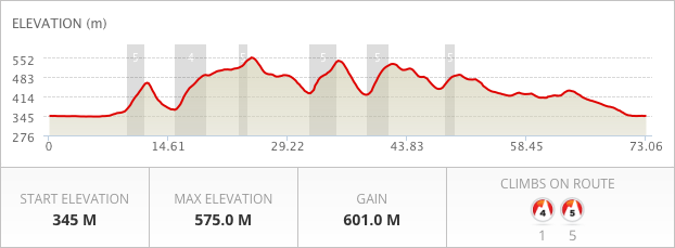
At just over 70km, this outing takes in a big chunk of the orchards and vineyards that provide East Kelowna with its distinct personality. This ride has it all. Some steady flat, some fast descents, and plenty of short and longer climbs to challenge you along the way. The bulk of the rise is on country roads, but there is a very short section on Hwy97 just after the airport. Plenty of Strava challenges dotted along the course and the strip behind the airport allows you to relive the infamous ‘Tom Cruise racing planes on a motorcycle’ Top Gun scene.
You can grab a snack and unique sparkling juice from Karma Farming (check their open hours) on McKenzie Road. But be sure to bring enough water and snacks for yourself, there are very few opportunities to stock up.
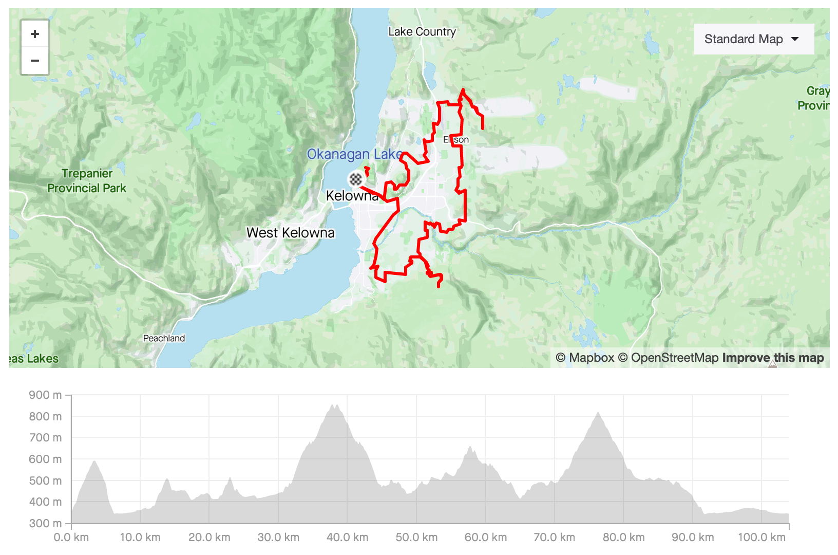
Kelowna's Climbs
Distance: 104 km (Vertical Gain: 1985m)
This difficult route is courtesy of OK Routes. It takes you up several of Kelowna's most epic climbs, winding along quiet backstreets with incredible views. The route itself is just over 100km with about 2000 m of vertical gain. It's not for the faint hearted or tired legged, but it's certainly worthwhile.
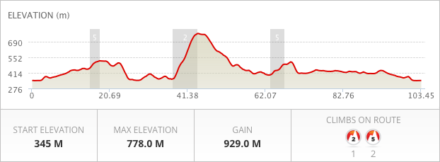
Skip through the downtown core and head up the first leg of Knox Mountain before heading into the more open areas of Glenmore. The main stretch of Glenmore Road has a narrow shoulder, if it has one at all, so be cautious, stay single file, and the traffic is usually well behaved. After a quick climb you drop into some great switchbacks heading down to Carr’s landing before shadowing the lakeshore through to Commonage Road where you start to climb up through the orchards. This is where the fun starts, a steady 7km climb up to the top of Predator Ridge. If required you can take a 5 minute detour to stock up on fuel or drink at the golf course stores. A long downhill drops you back onto the highway for a while before you head up around the back of Wood Lake. Another short highway stretch and you head back into Glenmore, reversing the first part of the ride back into town. Fuel stops are: In town, Carr’s Landing, Predator Ridge Golf Course, Pioneer Park (Oyama)